Community Concerns
Communities directly impacted have a long list of legitimate concerns about offshore wind farms. Which include environmental impacts like noise pollution affecting marine life, potential harm to fisheries from habitat disruption and barrier effect for migrating birds and whales. The visual impact is also a major concern for coastal communities along with the potential negative effect on their tourism and the fishing industries. The governments lack of planning of the marine environment is not setting Australia’s renewable energy transition up as a responsible one.Public Submissions
Following the "information sessions" (which were found wanting) the goverment called for public submissions regarding the proposed Gippsland offshore Renewable Energy Zone (REZ). People were not specifically asked weather they support or oppose this project, but the sumary report shows that just 11% of submissions wholeheartedly suport the Gippsland offshore project.Only in two of the six proposed REZ, people were asked the obvious question of do you "SUPPORT or OPPOSE" these offshore project. The result must have been a rude shock for the government, which saw Hunter REZ 66% OPPOSING and the Illawarra REZ 65% OPPOSED to offshore wind projects.
Concerns
The main concern for all six offshore Renewable Energy Zones is the potentual impact that offshore wind projects pose to the environment. Throughout the Gippsland submissions sumary report we find a number of common concerns with other communities impacted by these offshore Renewable Energy Zones. These being the adverse effects on the environment, migrating whales and birds, rookeries, fishing and spawning grounds etc. Other concerns from the Gippsland community include, impacts on penguins, seals, dolphins and the impact on reef and seabed habitats, particularly around Wilsons Promontory. Negative impacts on shipping were also mentiond.As is the case in all six Renewable Energy Zones coastal communitites like Ninty Mile Beach, who rely heavily on tourism and fishing. They fear the sustainabilty of their communities will be compromised, if these offshore wind projects go ahead.
Impact on Fishing
Lakes Entrance is the largest fishing port in Victoria and the south east of Australia, which contributes significantly to economic prosperity and employment in East Gippsland. Shark fishery is highly sustainable with strong stocks of sharks that produces high catch rates. The South East Trawl Fishing Industry Association (SETFIA) submission to the federal government, said the Gippsland Renewable Energy Zone would reduce seafood production. Fishers could lose 4,000 square kilometres or 400,000hectares (almost a milion acres) of shark fishing grounds in Gippsland because of so-called wind-farms.Fishing Fleet
The Lakes Entrance fishing fleet is Victoria's largest commercial fishing fleet with around 57 vessels, which opperate out of Lakes Entrance and fishing primarily in the Bass Strait. It is a historic industry that lands a significant amount of seafood, including blue grenadier, scallops, flathead, whiting, and gummy shark. Fishing exclusion zones and restrictions on the type or method used in and around wind-farms would desimate the fishing industry that could flow on to the tourism industry.Shark Fishing
The shark fishery is highly sustainable with strong stocks of sharks, which produce high catch rates. The Gippsland Renewable Energy Zone would reduce seafood production by about 300 tonnes, with an additional 85 tonnes predicted to be lost due to other Renewable Energy Zones in south-east waters.Spawning Grounds
Specific spawning grounds for offshore sharks are not precisely mapped for the Gippsland region, particularly the waters near Ninety Mile Beach and Corner Inlet. What is known is that it is a significant nursery and feeding area for species like gummy sharks. This is due to the abundance of prey like sand crabs and the presence of both shallow, sheltered areas and deeper offshore grounds. The area is also recognized as a habitat for other species.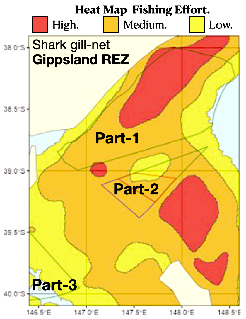
Fishery vs Gippsland REZ
Scallops
Commercial fishing for scallops has been part of the Victorian fishing industry since the early 1970's. The waters of the Victorian zone extend out to 20 nautical miles from the high tide water mark, but exclude the bays and inlets along the coast where commercial fishing for scallops is prohibited.Rock Lobster
The Rock Lobster Fishery is Victoria's most valuable commercial fishery. Almost all of the catch is now exported to international markets, mostly in Asia.Rock lobsters are a type of Southern or Eastern rock lobster that are caught commercially and recreationally in Victorian waters, including the Gippsland area.
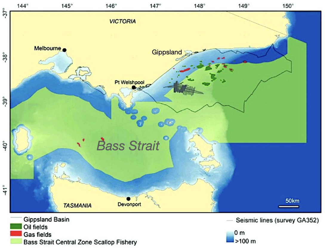
Map of the offshore Gippsland Basin, overlaid with Commonwealth scallop fishery and petroleum industry infrastructure.
Ninety Mile Beach
The offshore waters of Gippsland offer opportunities to catch gummy sharks, which are delicious to eat and more commonly encountered as flake from fish and chip shops. A significant population of gummy sharks reside off Ninety Mile Beach, which is home to lots of sand crabs, a favourite food of gummies.Beach fishing may not be directly impacted by offshore wind turbines, but the marine habitat that sustains target species would be impacted by 1,000 plus monstorous wind turbines, not to mention the visual impact just 10kilometres away.
Seabed Habitats
Trenching
Subsea cables are a critical component of offshore power staions (wind-farms), which conect the wind turbines in each array to each other and the offshore substations. Where the electrictity is converted from AC-to-DC for the tramission to an onshore substaion for conversion back to AC before entering the grid. The installation process involves a complex network of specialized vessels from overseas and engineering that would require thousands of kilometres of trenching and cable laying.Sedimentry Plumes
The physical presence of turbine support structures has an impact on ocean currents by slowing them down and increasing turbulence in their immediate vicinity. NASA satellite images from the Landsat 8 and Sentinel-2A satellites confirm that sediment plumes are created by wind turbines, which measure anywhere from 30 to 150 meters wide and up to several kilometers long downstream from offshore wind turbines.
Parks and Marine Protected Areas
Energy Minister Chris Bowen announced (Aug.2023) that the Renewable Energy Zone west of Wilsons Promontory would be removed from consideration for offshore wind development due to an "unacceptable environmental risks". His desicion to reduce the size of the proposed Renewable Energy Zone was the result of a sucesful campaign against this project to protect the Prom from the proposed offshore wind project. It appears the minister dosnt have a map of the area, because the threat remains to not only the Wilsons Pomontry National Park, but also to large number of parks, reserves and marine protected areas e.g. Beagle Marine Park.Wilsons Promontory
Also known as "The Prom," it is a national park and a peninsula that forms the southernmost point of mainland Australia, thats located in Victoria. Most famous for its rugged granite mountains, diverse wildlife and stunning beaches.Ramsar Site
The Gippsland Lakes Ramsar site is Australia's largest estuarine lagoon system, located in southeastern Victoria. Designated in 1982, it is internationally recognized for its significant coastal wetlands, diverse flora and fauna and its role as a vital habitat for migratory birds and threatened species.Gippsland Lakes Coastal Park
The park is a narrow, 17,600-hectare coastal reserve stretching along Ninety Mile Beach in Victoria, from Seaspray to Lakes Entrance. It features wetlands, coastal dunes, and the vast waters of the Gippsland Lakes system.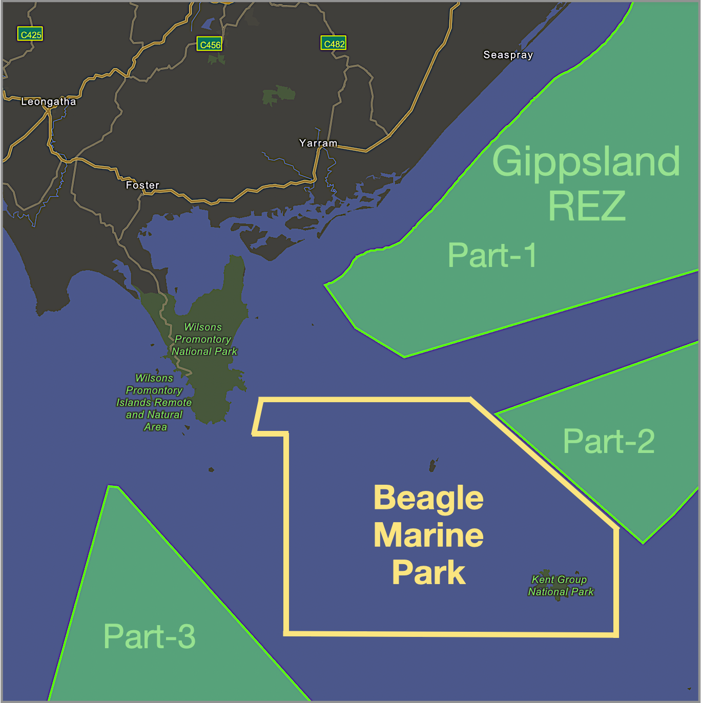
Gippsland Declared REZ
Beagle Marine Park
Beagle Marine Park is home to a variety of marine life, including thousands of Port Jackson sharks, diverse fish species like Degens leatherjackets and common gurnard perches, and various sessile invertebrates such as sponges, bryozoans, and hydroids on its reefs. The park also serves as a crucial feeding and migratory area for larger animals, including Australian fur seals, various species of seabirds like the short-tailed shearwater and migratory whales.Kent Group National Park
The reserve surrounds the Kent group of islands, which are in the middle of eastern Bass Strait. They are known for their high biodiversity, a result of the convergence of three ocean currents. The islands are a breeding sanctuary for the Australian fur seals who make their home on the rocky outcrops. The islands are also an important refuge for sea birds.Threat to Shipping
The risk of ships colliding with offshore wind turbines is a significant and growing concern for maritime safety on a global scale.Which can be atributed to factors such as human error, adverse weather and technical failures.
Not to mention radar interferiance created by the spinning turbine blades.
The risk is set to rise with nine European countries pledging to multiply the capacity of offshore wind farms in the North Sea by eight times current levels before 2050. Which means our concerns about ship colisions in and around wind farms are well founded, with 1,666 turbines in the Gippsland offshore Renewable Energy Zone.
Shipping Lanes
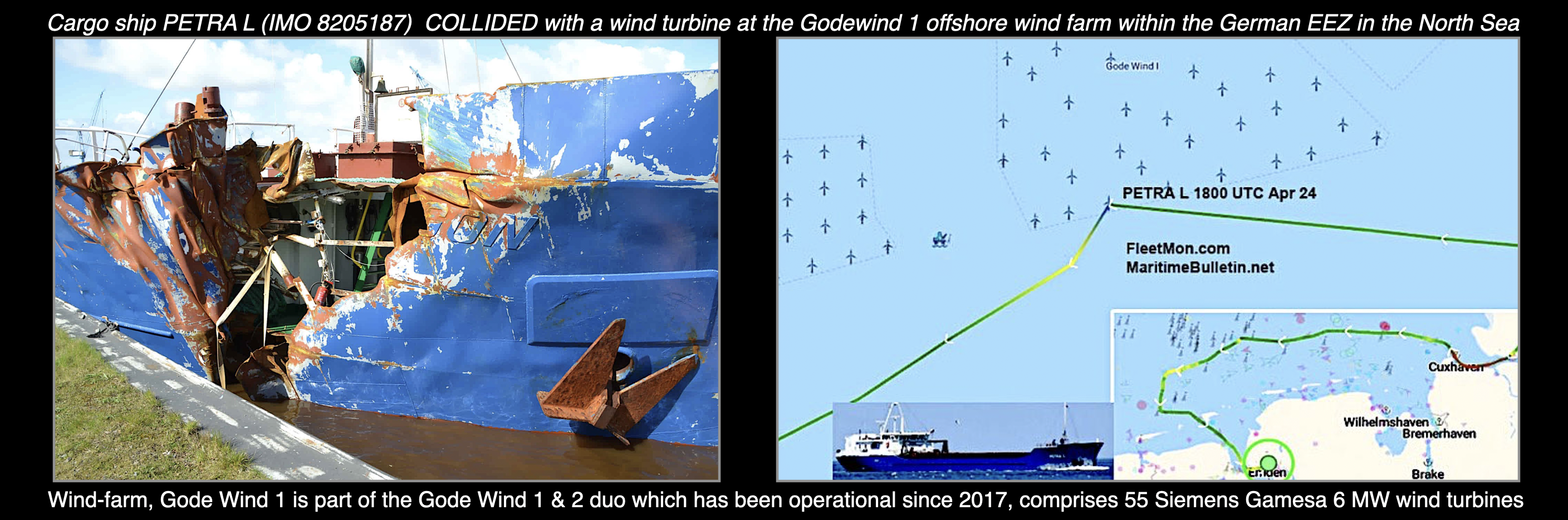
A number of reported cases of ships crashing into wind turbines. One example is the General cargo ship "PETRA L" that collided with a turbine at Godewind wind-farm pictured below. The crash site is NW of Norderney, Germany in North Sea. The collision happend in daylight hours, around 18:00 UTC (4pm German time), while enroute from Poland to Merksem Belgium with 1,500 tons of grain on board.Turbines bound for Australia are twice the size of North Sea turbines, which should make them easier to see.
Risk of Collisions
In Europe the concern is so great that they are researching and testing innovative crash barriers to protect wind farms. Which include floating buoys and submerged nets that can intercept and slow down drifting or offcource vessels before they hit a turbine.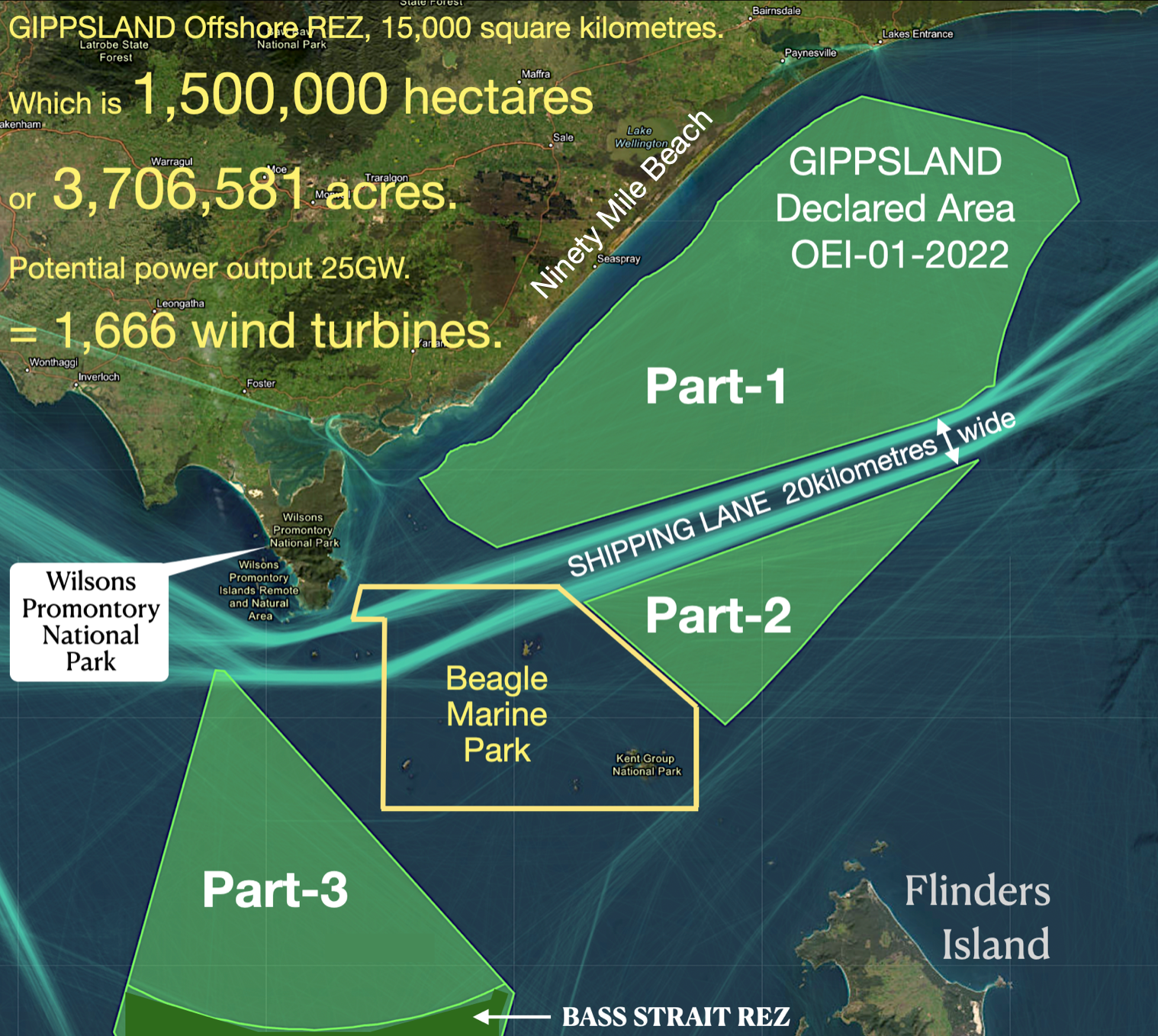
Green Lines AIS Tracking of Shipping.